Placename :
Kilgobnet
In Irish : Cill Ghobnait
Administrative Unit : Parish
 Pronunciation Audio File
Administrative Details:
Description:
Secluded, extensive, mountainous and, this parish is peculiarly favourable to place-name preservation. Local denominations of all kinds are accordingly both numerous and interesting. There is one river, the Colligan, and high up on the mountain, at the northeast angle of the parish, a couple of small lakes. Besides the Church from which the parish is named, there are sites of at least, three others.
Old Irish Typeface
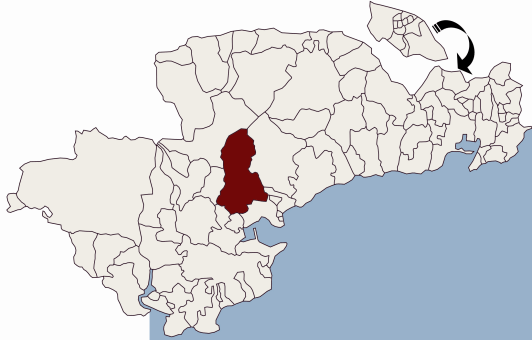
Parish Location Map:
Townlands:
Balleighteragh East,
Balleighteragh West,
Ballintoor,
Ballyconnery Lower,
Ballyconnery Upper,
Ballyknock Lower,
Ballyknock Upper,
Ballynakill,
Ballyneety,
Barracree,
Barracreemountain Lower,
Bohadoon North,
Bohadoon South,
Bohadoonmountain,
Carrowncashlane,
Coolnasmear Lower,
Coolnasmear Upper,
Coolnasmearmountain,
Coumaraglinmountain,
Currabaha,
Deelish,
Deelish-mountain,
Garranbaun,
Gliddane Beg,
Gliddane More,
Inchindrisla,
Inchindrisla Wood,
Kealroe,
Kilbryan Lower,
Kilbryan Upper,
Kilgobnet,
Killadangan,
Kilnafrehan East,
Kilnafrehan Middle,
Kilnafrehan Mountain,
Kilnafrehan West,
Knockaunagloon,
Monarud,
Monarud Mountain,
Scartnadriny,
Scartnadrinymountain,
Tallacoolmore,
Related Resources
To view full-text articles you will need to ensure you have Adobe Acrobat Reader loaded on your PC.
Online Books and Journals
Full-text monographs, journals, and articles of Waterford Interest include useful resources for Affane:
Placenames Database of Ireland
This is a comprehensive management system for official data, archival records and placenames. The public website is primarily aimed at journalists and translators, students and teachers, historians and researchers in genealogy. It is a public resource for Irish people at home and abroad.
|